
Wouldn’t it be fabulous to be able to take students on a field trip to all of the places we have them learn about? Well, you can… sort of. Just have your students hop on the Google Maps magic bus with you and you’ll be exploring those places virtually in no time!
Whether you just want to get the bird’s eye view of a location using Satellite View or to use Google Street View to get a closer look, here are some of my favorite ways to use Google Maps to bring your lessons to life:
- Explore Places in Stories
I’ve just finished reading Serafina and the Black Cloak by Robert Beatty. It takes place at the Biltmore House in Asheville, North Carolina. It’s hard to imagine a home like this. Use Google Maps to take your students on a tour of the grounds. Then use the images from the sidebar to get them and idea of opulence of the decor.
Take it a step farther and use Street V
If you have access to Google Earth, you need check out Google Lit Trips. These are guided book tours. Lit Trips come in the form of overlays that can be opened in Google Earth. They provide pop-ups of additional information about the story, time period and places in the books.
2. Science and Landforms
Take a walk through the Mojave Desert or stand on the edge of a volcano. Using Google Maps in Satellite V
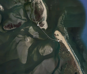
If you’ve ever watched Wicked Tuna: Outer Banks, you hear the fishermen talk about how dangerous Oregon Inlet can be because the channels constantly shift. By looking up Oregon Inlet in Google Maps, you can see the maze of channels they must navigate to get to the ocean.
3. Prepare for a Field Trip
Every year our 4th grade students would take a trip to our state’s capital. There’s not always time to point out every important landmark and building they walk by. Using Google Maps you can take students on a pre or post-tour of the area to share more details. It can even be used as an assessment of sorts to see what they remembered from the trip.
Google Maps can be a great planning tool as well. You can get a lay of the land to determine the best walking routes, places to park and landmarks to see. If you use street view’s blue and orange dots to get a closer look at the monuments and grounds you can having talking points to share with your students.
4. Don’t Forget about Math!
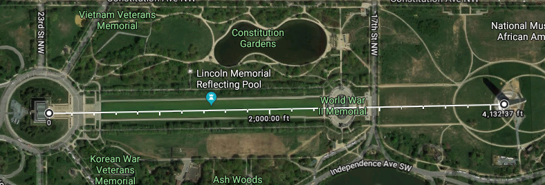
Google Maps even has a tool that helps to bring a little math into the equation. Let’s say you wanted to get a rough idea as to which building had the greatest area or perimeter or find the distance between two objects. When you right click on the image, select Measurement Tool. From there you can click around the building or from one end to the other. The measurements are calculated at the bottom. For instance, it is approximately 4,132 feet from the Washington Monument to the Lincoln Memorial.
To turn off measurements, simply right click and select Clear Measurement.
5. Explore Culture
So, next time your lesson involves a place or a building, don’t just talk about it. Take them there and let your students explore!
When learning about different cultures and studying countries Google Street view can give you an insight into other locations. Visit different locations. Have students note differences in clothing, architecture and sights they notice as they travel through the area. They can note similarities and differences they find based on their own area or culture.